A geological window on the past
The Swiss Tectonic Arena Sardona, a Unesco site since 2008, shows how mountains were built and is of vital importance for understanding plate tectonics.
Its setting in eastern Switzerland, is well-known for its breathtaking Alpine scenery and mountain lakes.
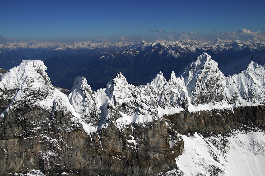
Since the end of the 18th century this area has also been of great interest to scientists because of an outcrop of rock approximately 35 kilometres long and 25 km wide. It rises to more than 3,000 metres in several places in the Hausstock-Sardona-Ringelspitz region.
Along the “Glarus overthrust”, rock formations 250-300 million years old are superimposed onto much younger rocks, dating back 35-50 million years.
“Like many other overthrusts, this example in the Glarus Alps is visible evidence of the dynamics of plate tectonics,” explained Carlo Ossola of the Federal Environment Office, who oversaw the process leading to the site’s Unesco listing.
“In this case, though, the visibility of the overthrust is quite exceptional, giving it a unique global importance.”
When scientists first began studying the formation of the Alps, they could not understand why, in the Glarus region, an enormous nappe of older rock was superimposed on a younger one.
Overthrust
It was not until around 1950, after further studies of fault dynamics and the development of plate tectonics theory, that geologists concluded that it was the result of an enormous overthrust.
“We have to imagine that the African plate, pressing on the European one, pushed a ten-kilometre-high mass of rock up and over another formation,” explained Kaspar Marti, manager of the GeoPark around the site.
“This all occurred at a depth of between six and ten kilometres, where temperatures ranging from 320-400°Celsius made the rocks less compact and enabled the overthrust to take place along a fault plane of limestone. Then, when the earth’s crust rose, the whole area came to the surface.”
Marti said that the phenomenon was not recognised until around a century ago.“It seemed inconceivable that a mass of rock ten km high could be displaced for 35 kilometres,” he said.
“Now, however, it is generally accepted, and is explained in terms of plate tectonics, hence the name ‘Swiss Tectonic Arena Sardona’. And it was largely here that the theory was developed.”
“Magic line”
The Glarus overthrust, extending over an area of more than 300 km², is easily recognisable: the uppermost and older layer is reddish rock with occasional shades of greyish green; the younger underlayer is grey-brown and, has, deeper down, the black colour of flysch sedimentary deposits.
The two layers of rock are divided by a continuous narrow groove commonly referred to as the “magic line”.
“Although in theory this line runs along the whole area affected by the overthrust, in practice it is not visible everywhere, having disappeared in many places due to erosion,” added Marti.
The line you can put your hand on at the Lochsite also runs via the Tschingelhoren, Piz Altas or Piz Sardona peaks, and is also clearly visible from the towns of Elm in canton Glarus or Flims in canton Graubünden.
Marti says the line is slightly deceptive . “It was probably formed following an earthquake and a shift in the covering of rock, but at a stage later than the overthrust itself.”
Exceptional example
The geomorphologic details of the overthrust can be observed closely at many parts of the site. Most are at altitude and can be reached by walking for several hours on beautiful mountain trails, but there are some, such as the Lochsite near Sool-Schwandeng, which are very easily accessible.
“The Lochsite is one of the lowest sites in this protected area, just over 500 metres above sea level, and easy to reach by a well-maintained path,” said Ossola. “And there are plans to make it even more accessible, because part of our mandate is to open up the site and teach people about plate tectonics.”
Seen from a distance, the geological details become blurred – it is difficult to make out the fault in the chalky rock, and the division between the two nappes is marked only by the fascinating “magic line” as it rises slantwise among the various peaks.
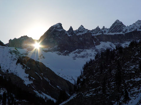
From Elm, you can see it crossing the slope of the Tschingelhoren and by passing the Martinsloch (2,600 metres), the famous Martin’s Hole or natural window – probably formed when the rock gave way under great pressure – through which the sun and moon can periodically be seen.
But there is also evidence below. Among the Alpine meadows and gurgling streams is a scattered mosaic of red and grey-green rocks, which also tell the story of how the Alps were formed.
Paola Beltrame in Elm, swissinfo.ch
The Swiss Tectonic Arena Sardona in the north-eastern part of the country covers a mountainous area of 32,850 hectares which features seven peaks that rise above 3,000 m.
The area displays an exceptional example of mountain building through continental collision and features excellent geological sections through tectonic thrust, i.e. the process whereby older, deeper rocks are carried onto younger, shallower rocks.
The site is distinguished by the clear three-dimensional exposure of the structures and processes that characterize this phenomenon and has been a key site for the geological sciences since the 18th century. The Glarus Alps are glaciated mountains rising dramatically above narrow river valleys and are the site of the largest post-glacial landslide in the Central Alpine region.
Source: Unesco

In compliance with the JTI standards
More: SWI swissinfo.ch certified by the Journalism Trust Initiative
You can find an overview of ongoing debates with our journalists here. Please join us!
If you want to start a conversation about a topic raised in this article or want to report factual errors, email us at english@swissinfo.ch.